Property lines set the legal limits of your land, but they often remain invisible to the naked eye. Many landowners wrongly assume that fences, tree lines, or roads mark their boundaries, when these features might be off by several feet or even yards. Official property lines come from legal surveys recorded in deeds and county documents. Knowing exactly where your land begins and ends prevents disputes with neighbors, ensures proper placement of buildings and fences, and provides clarity for hunting or recreational use.
Finding Your Property Boundaries
Property Deeds and Plat Maps
Your property deed contains a legal description of your land boundaries, though these descriptions can be difficult to interpret without training. They typically use one of three methods: metes and bounds (distances and directions), lot and block (for subdivisions), or government survey system (township, range, and section coordinates). Plat maps provide visual representations showing property dimensions, shapes, and relationships to neighboring properties.
County Records and GIS Tools
Most county assessor or recorder offices maintain property records that include boundary information. Many counties now offer Geographic Information System (GIS) maps online that show approximate property lines. While helpful for visualization, these digital resources typically come with disclaimers about their precision and may be off by several feet. GIS maps provide good starting points but should not be used for final boundary decisions when building or installing fences.
Professional Land Surveys
When absolute accuracy matters, hiring a licensed land surveyor remains the gold standard for marking property lines. Professional surveyors combine historical records with precise measuring equipment to establish definitive boundaries. They research previous surveys, property deeds, and other records before conducting field measurements. A professional survey typically costs between $300 and $1,000 for residential properties, with larger parcels costing more based on acreage, terrain complexity, and existing documentation.
How to Mark Property Lines Yourself
If you need to mark property lines for general understanding rather than legal purposes, several approaches can help you approximate your boundaries between professional surveys.
Locating Existing Survey Markers
Professional surveyors place markers at property corners and significant boundary points. These might include iron pins or rods (sometimes with plastic caps), concrete monuments, chiseled marks in stone, or metal disks. These markers are often buried just below the surface or hidden by vegetation. A metal detector can help locate buried iron pins near sidewalks, road edges, and apparent corners of your property line.
Using Measurements and Basic Tools
If you have a property survey with clear measurements, you can use basic tools to recreate your boundaries. Long measuring tapes (100+ feet), a compass for directional bearings, string lines between known points, and wooden stakes with flagging tape can help you mark rough boundaries. Start from a known marker and follow the bearings and distances listed in your survey, which works best for simply shaped properties.
Modern Technology Options
Several smartphone apps and handheld GPS devices can help mark property lines if you have coordinates from surveys or county records. Consumer GPS typically offers 10-30 foot accuracy, while specialized surveying GPS can achieve much greater precision but costs significantly more. Smartphone boundary apps often use county GIS data, which carries inherent limitations in accuracy but provides helpful visualization of property boundaries.
Legal Considerations When Marking Property Lines
Before placing permanent markers or making boundary decisions, understand that only licensed surveyors can legally determine property boundaries in most states. DIY marking serves as personal reference rather than legal establishment. Some municipalities require permits for fence installation or boundary marking, and removing or altering official survey markers may violate local laws.
One of the best ways to prevent boundary disputes is through clear communication with neighbors. Inform adjacent property owners of your plans to identify property lines, share survey information if available, and document any boundary agreements in writing. This transparency helps maintain good relationships and prevents misunderstandings that could escalate into legal issues.
When Professional Surveys Are Essential
Professional land surveys provide legally defensible documentation of your property boundaries. For real estate transactions, surveys give both buyers and sellers clear understanding of the land being transferred. Many mortgage lenders require recent surveys before financing property purchases, especially for vacant land or large parcels.
Construction projects nearly always benefit from professional surveys. Before building structures, installing fences, or creating driveways, confirming exact property lines prevents costly mistakes and potential legal conflicts. Many building permits require survey documentation showing that structures will remain within property boundaries.
Boundary disputes with neighbors almost always require professional survey resolution. When disagreements arise about property lines, professional surveys provide evidence that courts and local authorities recognize as valid. In these situations, the cost of a survey often pales in comparison to the potential legal expenses of protracted boundary conflicts.
Maintaining Property Boundaries Over Time
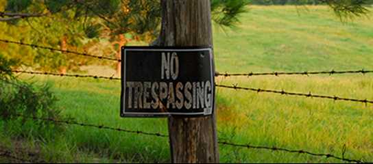
Property markers can deteriorate, become buried, or disappear entirely over time. Creating a regular schedule for checking and refreshing boundary markings helps maintain clarity. Walk your boundary lines annually, clear vegetation around markers, and refresh paint or flagging on trees or posts along property lines. For hunting or timber properties, maintaining visible boundaries also helps prevent accidental trespassing.
Keep thorough records of your property boundaries by storing paper copies of surveys in a safe place, creating digital backups, and taking dated photographs of survey markers with identifiable landmarks. Record GPS coordinates of key boundary points when possible. These records prove invaluable if markers are lost or disputes arise later, potentially saving the cost of completely new surveys.
Finding Land with Well-Established Boundaries
When purchasing property, boundary clarity should be a key consideration in your decision. Ask sellers specific questions about property lines: When was the last professional survey completed? Are survey markers visible and maintained? Have there been any boundary disputes with neighboring properties? Are there any easements or encroachments affecting the property lines?
Look for properties with recent surveys and clearly marked boundaries, particularly when buying rural or recreational land. Properties that back up to public lands, waterways, or roads may have more complex boundary issues than those surrounded by well-established private properties. If purchasing land for hunting or recreational purposes, well-marked boundaries help prevent trespassing concerns and ensure you are utilizing your entire property.
Land specialists at Mossy Oak Properties understand the importance of clear property boundaries. Our agents can help identify properties with well-documented boundaries and explain any potential issues before purchase. This expertise helps prevent buying land with unclear ownership limits or ongoing boundary disputes. When investing in land, proper boundary marking creates confidence in your purchase and enjoyment of your property for years to come.